|
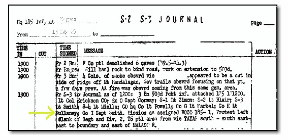
After my January trip I contacted John Lindgren for advice, and he mailed me the maps I needed to follow the 503d. Jim Mullaney also provided me information from notes he kept on the battlefield, as did the writings of Chet Nycum and John Reynolds. I must mention that I was specifically looking for the route of G Company, my father being in its Third Platoon. An additional consideration in tracking G Company is that from May 13 to May 26, 1945, Third Battalion was left in the mountains with the 185th Infantry Regiment of the 40th Infantry Division, while First and Second Battalions deployed about fifteen miles south, through Murcia, to attack in the direction of Hill 4055. This meant that Third Battalion records were kept by the 185th Infantry Regiment for those two weeks. In July 2004 I traveled to the National Archives in Maryland and found and photocopied the S-2/S-3 journal of 185th Infantry Regiment for the Negros campaign. Third Battalion activities were well documented in this log. On 13 May, 3d Bn 503d PRCT, linked up with the 185th Infantry and remained in the mountains, whilst the 1st and 2d Battalions were deployed to attack in the direction of Hill 4055.
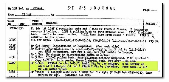
My goal was to reach the areas called �high ground� and �incident� on the GPS map. The 503d fought for the �high ground� from April 21 through April 28, 1945. After taking it, the Japanese began to fall back quickly into the mountains. In the area labeled �incident� my father was involved in a mine explosion on May 23, 1945, described in the 185th journal. One trooper, Fred Blomfield, was killed by the mine, and two others were wounded. My father was shielded by a tree and not injured. I plotted coordinates for G Company movements from 503d and 185th records on the maps John Lindgren had provided and got a clear picture of the company�s route. I then converted some of the plots to latitude and longitude for use with the Global Positioning System (GPS). Having GPS with me was essential. There are no current maps or clear high resolution aerial photographs of the battlefield area available The Philippine Mapping Agency, Fort Bonifacio, sells map sheets derived from US Army publications of the mid-1950�s, which were based on aerial photography dating from 1947. Although the topographic information on them is still valid, most mad-made features have changed substantially. Further complicating navigation is that Filipinos generally use different names for landmarks than what is in the military records. With GPS I always knew exactly where I was. I had programmed reference points such as villages and mountain peaks into the GPS before the trip.
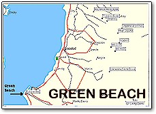
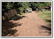
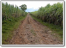
On my September trip I hired a Jeepney to first follow the 503d invasion route, the Tokaido Road, as far as possible. We drove from Silay to Hacienda Hinacayan, now a small village, the kick off point for the 503d on April 9, 1945. An unmarked sugar cane road leading southeast out of town is the Tokaido Road. I expected to find a railroad track for reference, but the locals told me it had been removed by Hawaiian Pineapple Corporation. They did show me the track bed. My guide said we could not follow the Tokaido Road past Napilas, as no established hiking paths exist.
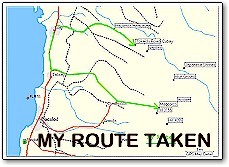
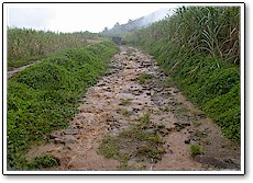
I then had two options to get to the 503d main battle area. Walk in via established paths beginning from Japanese shrines shown on the GPS map, or drive in via a sugar cane road that goes east of Talisay to the foot of Hill 3155 (also called Dolan Hill, after Lt John Dolan, commander of Company C, 160th Infantry Regiment, 40 Infantry Division, killed there on April 20, 1945). I chose the driving trip. We could only make about five miles per hour over this extremely road, but arrived conveniently at 2000 feet of elevation, at the base of Hill 3155, labeled Magcorco on the GPS map, before having to walk. Unfortunately, as we were ready to walk into the area, heavy rains arrived and prevented me from going. The rain was so frequent and heavy I decided it would be better to come back during dry season, rather than rehire the guide and vehicle the next day. Also, the sugar cane fields are burned during dry season which would improve visibility. I learned a few lessons on these trips. First, you must bring all information with you. Nothing specific is available locally regarding the 503d. Second, GPS is ideal for exploring the battlefield. I can't emphasize enough the importance of having GPS on a trip like this. It is physically difficult to travel anywhere on this battlefield, and it is nice to know exactly where you are when you are investing a lot of effort to move around. GPS eliminates reliance on using names to navigate. The Filipinos use local names that usually differ from military records, and compounding the problem is that my guide didn't speak English very well, as will be true of many of the people living in rural Negros. Another problem is that the Filipinos are not used to using maps. When you live your whole life within a few square kilometers, you don't need to learn map reading. The sugar cane fields, dirt roads, mountain peaks are difficult to distinguish with the lack of current maps or aerial photography. Obtaining information from locals is unreliable because of problems with names. For instance, there are seven different settlements named Napilas in the vicinity of Silay. They are all likely derived from a single extended family, but this guarantees confusion if you ask for directions. I plan to make one more dry-season trip to finish exploring the battlefield. A guide suggested a walking trip from the Japanese monument area along �Secret Trail� to Murcia. He told me this takes two days for a �strong hiker�, with one night spent in the mountains. I will be satisfied to reach the limits of the Third Battalion�s movements, which is near the spot labeled �incident� on the map. I may also go to the foot of Hill 4055, by vehicle through Murcia, to at least see the terrain of 503d operations which occurred there from May 12 through June 7, 1945. I may also try to find the spot of Gen Kona�s surrender at Hacienda Santa Rosa. There are likely people in the area who would know where the ceremony occurred. Another possibility is chartering a private airplane to fly over the battlefield and take some high quality aerial photographs. Prior to my visit, I did some research regarding the sugar industry on Negros. It is not a pretty history. The labor policies are right out of the middle ages. To avoid minimum wage laws the sugar cane is sometimes paid for as piecework or by kilogram. I was interested to see that the US gave the Philippines special status following WWII regarding sugar shipments to our market. The idea was to help the Philippines recover from the war. This special status continued through the 1970s, probably for domestic political reasons. Although it did make a few people wealthy, the net effect was damaging both to the industry, and to the community. Because they had a guaranteed market, the owners lost interest in modernizing. They also put marginal land on the mountain slopes into production because they knew they could make a profit selling into the US market, even though this led to erosion problems. When preferred access to the US market disappeared because of changing market conditions and politics, the industry on Negros was uncompetitive in comparison with the more mechanized production in other countries. To this day they compensate by paying absolutely bottom level wages. This leads to the social problems which breed the NPA etc. Local authorities have tried to get sugar cane workers to diversify what they plant, and to learn other skills, but old habits die hard. If their father worked sugar cane, the children do also. Virtually the only way to break the cycle is to get an education.
Finally, don�t go to Negros during rainy season. It not only rained each afternoon, but at night as well. The rain was so heavy one night it sounded like a freight train passing through my hotel. I wonder how it sounded under my father's poncho. Steve Foster |
|||||

|
|||||
|
My Uncle, Al Alessandra joined the
27th Inf Div, and assigned to the 40th which according to My Uncle Guy who
was on Leyte (8th Army), went into combat on Negros Island. He was
killed in action on April 22, 1945. I was wondering if you have any
knowledge or contact with the other units such as the 40th, on Negros,
when you were in combat, since you were in combat during this same time.
Al Alessandra |
|||||
|
� 2004 Steve
Foster |
|
||||