|
COMMENTARY
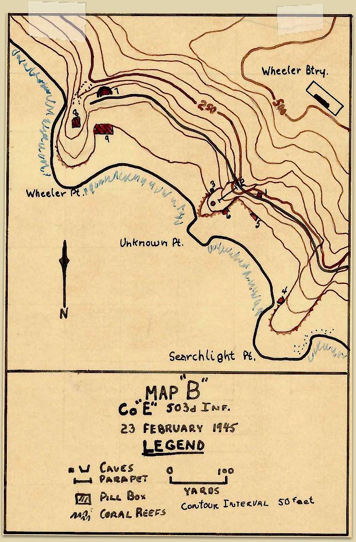
NOTES CONCERNING HUDSON HILL'S MAP B
THE AREA FROM SEARCHLIGHT POINT TO WHEELER POINT
MAP POINTS
Map Point 1 - Fortified
cave
Map Point 2 - Even in February 1945,
the South Shore Road was "what used to be a roadway." It was
by then a twisted, barren slope of loose sand, boulders and
debris. A destroyed truck
remained parked on it near Noname Pt. The truck concealed a
gun pit dug underneath.
Map Point 3 - Fortified
cave
Map Point 4 - Fortified
cave; Hill says that from
the gun pit on the tip of the point it was possible to see
and fire directly into the natural cave at Point 4, which
would yield a reported 7 Japanese dead.
Map Point 5 - Fortified
cave / Barricaded Tunnel - Hill says the opening
of the barricaded tunnel at point 5 could be seen from a
vantage point on Topside, but that it was possible to fire
into the tunnel mouth at only a very sharp angle. A trench
capable of holding about 12 men had been dug across the
interior of this tunnel, allowing them to stage a
short-lived Banzai attack. This trench and barricade
accounted for the Japs being able to withstand a tremendous
volume of fire being put into the entrance. Examination of
the tunnel, after Lt. Crawford's successful attack, found a
total of 47 dead Japanese, 41 rifles, and a badly damaged
heavy machine gun.
Map Point 6 - Fortified
cave - Small Cave at Unknown Pt: The small cave
at point 6 could not be seen, nor could it be fired upon by
the LMG’s still on Searchlight Point.
Map Point 7 - Fortified
tunnel entrance - Fortified tunnel entrance. Hill says that
"This
tunnel led back to the underground magazine of Crockett and
Wheeler Batteries," which is just entirely wrong. It was the
entrance to Battery Monja. Inside, it branches to the left
(towards the gun at Point 8) and to the right (towards the
gun's powder and shell rooms.) There was no access tunnel
between this tunnel and any other Battery. As Hill hasn't
been inside the tunnel, indeed, no American was able to
enter the tunnel as it remained firmly in Japanese control
until 1 Jan 1946) he is being fanciful.
Map Point 8 - Concrete
fortifications - most likely Battery Monja itself.
Map Point 9 - Concrete
fortifications
-o-0-o-
As far as we have seen, there is no formal naming of the
geographical point which lays between Searchlight Pt. and
Wheeler Pt. American maps do not label it, and consequently
it has been referred to variously as "Unnamed Pt" and "No
Name Pt." A wartime Japanese map, which does have it
labeled, translates phonetically to "Mona", which clearly is a reference to Monja
Point. This introduces only further confusion, as Battery Monja
is on Wheeler Pt,, not on Monja Pt. Accordingly, we
shall refer to the area as "No Name Point."
Geologically speaking, there
are no natural caves on Corregidor. It is an island of
igneous rock, the volcanic rim of a long extinct parasitic
cone. All the so-called caves were man-made tunnels.
Hill can't be faulted for this, as it's an easy habit that
everyone has fallen into at one point or another.
|